Kansas Department of Health and Environment (KDHE)
Kansas Environmental Interest Finder (KEIF) App User Guide

Welcome to KDHE's Environmental Interest Finder (KEIF) web application! This web app is provided as a public service through KDHE and is intended to provide general information. For further information or environmental concerns, please contact the originating KDHE program in the Division of Environment.
The use of names or addresses derived from public records for commercial purposes is expressly prohibited under Kansas law (K.S.A. 45-230).
Table of Contents
Search for location
- Address or any text
- Manual navigation
- Legal description
- Latitude/longitude – XY coordinates
Environmental Interests Information
- Pop-up information
- Export list of environmental interests in my area
- Only see certain environmental interests in my area
- Find out more information about an environmental program
Other Tools
- Backgrounds (Basemaps)
- Print map
Map aplication drawing problems
Environmental interest points drawing problem
About
Frequently asked questions
- How do I find all the KDHE Environmental Interests in my Area?
- Who do I contact if I want to find out more information about a particular KDHE Environmental Point of Interest?
- Should I be concerned or alarmed about every environmental interest in my area?
Back to top
Search for location
Address or any text
- A "Find address or place" search box is located in the upper left corner of the map.
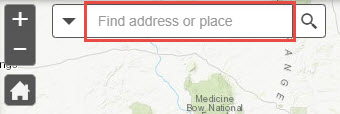
- Start typing an address, city, zip code, or another name in the box.
- A list of suggested matches will appear if a match is found.
- Click on one of the matches to zoom to that location on the map.
Manual navigation
- Use the mouse scroll wheel to zoom in and out of the map. Click/tap and drag to pan in any direction.
- Click the + and - buttons to zoom in and out of the map, respectively.
- Click the house button to go back to the starting view for the map (usually the entire state of Kansas).

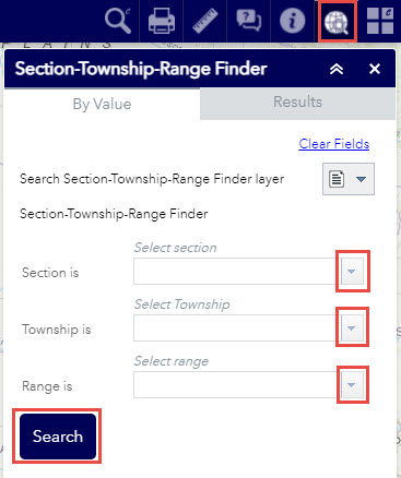
Legal description
- Click on the Section-Township-Range Finder button in the top toolbar.

- Use the drop-down menus to select the section, township, and range desired.
- Click Search to zoom to your selection.
Latitude/longitude – XY coordinates
- Type longitude and latitude (in that order) separated with a comma. Example: -95.677,39.046
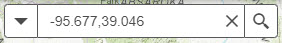
- Make sure to include the "-" negative sign with the longitude value.
- Press enter or click the magnifying glass button to search for that location. The map will zoom to that location.
Back to top
Environmental interests information
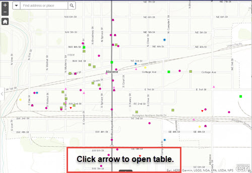
When you are zoomed in close enough, any environmental interests in the area will appear on the map. Click on the arrow at the bottom of the map to open a table with a description of the interests within that view.
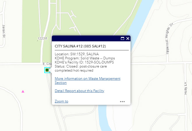
Pop-Up Information
- Click on a map symbol to see a pop-up identifying the point of interest.
- Many points may be located at or near the same location. There will be a scroll option with arrows at the upper left of the pop-up.
- Inside the pop-up, there is a hyperlink to the related web site with more information about that particular program.
- Some pop-ups will contain a hyperlink to a more detailed report about that site. These are made available when a KDHE Program has an existing public reporting tool.
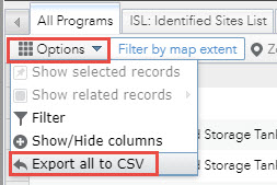
Export list of environmental interests in my area
- Click on the arrow at the bottom of the map to open a table with a description of the interests within that view.
- In the top left corner of the table, click on Options > Export all to CSV
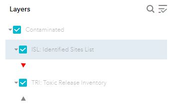
Only see certain environmental interests in my area
- The Layer List tool is open by default on the left side of the screen.
- Use the Layer List button in the upper right menu to close or reopen the tool.

- Uncheck a box to hide its contents on the map.
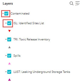
- The table will also show/hide environmental interests based on what is checked in the Layer List.
- A layer in the list will turn gray if it is not visible at the map's current scale. Zoom in further to view.
Back to top
Other tools
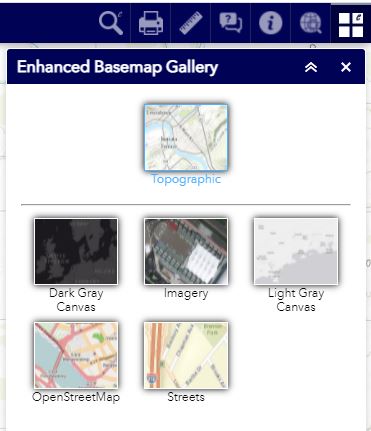
Backgrounds (Basemaps)
- Different backgrounds (or basemaps) are provided to suit different personal preferences.
- Click on an image to change the background.
- All backgrounds are served by Esri. For more information about ESRI basemaps visit https://www.esri.com/data/basemaps
Print map
- Use the Print tool to create a formatted pdf of the visible area in your map along with a legend, title, scale, and disclaimer.
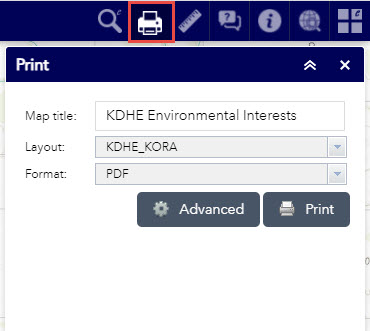
- Please be patient! Creating the pdf may take a few minutes depending on the internet speed and scale of your map.
Back to top
Map application drawing problems
- Use your internet browser's "refresh" button if the map fails to load completely.
- If refresh does not fix the issue, try clearing your browser's cache to force a full reload of the app. One way to do this is to open your browser and press Ctrl + Shift + Del on your keyboard. This will open a window with several options for clearing stored settings. In Internet Explorer, you’ll want to check the box for Temporary Internet files and website files. In Microsoft Edge, check the box for browsing history and caches images and files. In Google Chrome and Mozilla Firefox, you’ll want to check the box for Cache. Once you clear your cache, refresh the page (F5 on your keyboard) and you should see the map. If you’d like to learn more about browser caches, visit http://refreshyourcache.com/en/cache.
- A high-speed internet connection is recommended, at the minimum of 24 mbps.
- A minimum screen resolution of 1024 x 768 is recommended.
Back to top
Environmental interest points drawing problem
Please double check the "Drawing Problems" section. The points of interest symbols have a scale threshold and will not draw until zoomed in close. If the points still fail to draw, the mapping service may be temporarily unavailable. Please contact the KDHE webmaster at webmaster@kdheks.gov to see if this is the case. As a friendly reminder, this application is not supported 24/7 so responses will occur during normal business hours.
Back to top
About
This web map is provided as a public service by Kansas Department of Health and Environment, Office of Information Technology Services. It was first made publicly available in July 2014 using the Esri Flex 3.6 API and ESRI ArcGIS Server 10.2.
Back to top
Frequently asked questions
How do I find all the KDHE environmental interests in my area?
Use one of the "Search for Location" methods to zoom the map into your area. Once the map has zoomed into an area, the Environmental Interest points can be clicked on in the map to find out more information about that particular point. All the points in the map extent will also be listed in the grid below the map. Using the Table Options, you can save this grid and print it.
Who do I contact if I want to find out more information about a particular KDHE environmental point of interest?
There are a few methods for obtaining more detailed information about a particular KDHE environmental point of interest. First, click on the point in the map to view a pop up with more information. Many KDHE programs have publicly available reports about sites. If a report is available, there will be a link in the pop up that should open that particular environmental point of interest report. Current KDHE programs with detail reports include ISL, Spills, Tanks, and Solid Waste.
If you still more information, please visit the Kansas Open Records web page to learn more about making an official request. Please reference the PROGRAM ID along with the name and address to streamline the process of reviewing your open records request.
Should I be concerned or alarmed about every environmental interest in my area?
No. Many environmental interest points shown in this map are listed because they are regulated by KDHE and the Environmental Protection Agency (EPA). These regulations are in place to protect your health and the environment for both current and future generations. Many of the sites identified as contamined have been restored to their original state.
Back to top